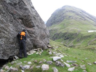
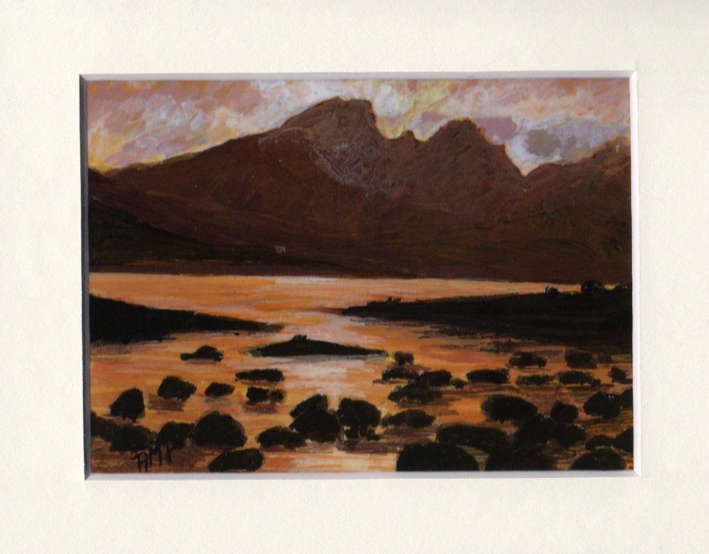
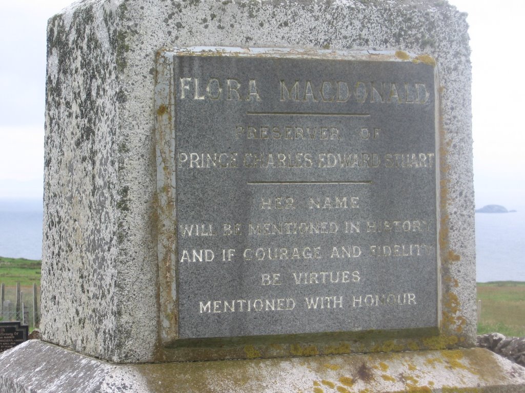
 Blaven: Artist's conception ...
  ... and what we could see.Preface: This is not the part of our recent trip to Skye that I necessarily want to remember most, as loaded with some still-raw emotions--and skin--as it is, nor was it the first thing we did, but it's the part that right now seems to be in the forefront of my mind, so I'll write about it first. To be fair, Mrs. Werbenmanjensen also deserves to post and/or comment on it, so we will undoubtedly be hearing from her.Editor's note: For those of you waiting for the Tale of the Trousers, this is it. Read on.
In 1891, Sir Hugh Munro published a table of all of the mountains in Scotland 3,000 feet or more above sea level, which today, after review and revision, number about 284. With the publication of such a list, there are those who of course make it their goal to hike up as many of them as they possibly can. As the author Cameron McNeish notes in his indispensable book
The Munros, (I say indispensable because every gift shop in the Highlands seems to sell it):
When Sir Hugh Munro drew up his tables he could scarcely have realized the consequences. I wonder what he would think today if he knew that his surname had become a generic term for Scottish mountains over 3000 feet? I wonder what he would think of the legions of people who refer to themselves as Munro-baggers rather than walkers, climbers or hikers? What would he think of the poor souls who have suffered premature dementia of because of a continued struggle to climb mountains for the prime purpose of ticking them off in a book? Or if he heard his name taken in vain as the afflicted souls toil up their umpteenth Geal Charn in snow, sleet and wind for the pleasure of following their compasses all the way down again?
Mrs. W and I have bagged a munro once before, during our honeymoon walking tour of Scotland. On what was scheduled as our "rest day" between inn-to-inn walks ranging from five to 10 miles, we were staying at a bed-and-breakfast on Loch Hourn that just happened to back up on a mountain called
Beinn Sgritheall (pronounced
byn skreehal), and the lure was just far too much for me to resist.
(Now before any readers from the western part of the United States chime in with smart aleck comments about how deep they would have to dig a well to reach 3,000 feet, let me just point out very quickly that to hike many of Scotland's munros you must start at sea level. Therefore, bagging a
fourteener when you start at 11,000 feet is no more impressive, mmm-kay?)
The less said about our first munro expedition, I suppose, the better. Our host set us down on the road with the instructions, "Walk up the hill about a quarter of a mile. When you reach an old stone wall, follow it until it peters out, and then you can't miss the trail." Many hours of hacking through head-high ferns, walking clumsily over boulder-sized riprap, churning clumsily through loose scree, yes, we did find the trail--about an hour or so before we got to the top of the mountain. Several times I proposed turning back, but Mrs. W's determination was much stronger than mine. After all, the top looked
just so close. McNeish suggests the hike takes four to six hours to complete. For us, six hours was just to reach the top. The descent took us over a knife-edge ridge, down a track cut into a very, very steep face, and through a slippery path that shared space with running water. It was a very hard day physically and emotionally for us, but was an early test of how we work together as a married couple. There was a somewhat dangerous tumble, some doubts about whether we were going to make it off the mountain by nightfall, hunger, thirst, and toward the end, complete exhaustion. But we made it.
The second trip wasn't much different--but I'm getting a little ahead of myself.
On Skye, the landscape is dominated by a series of peaks known as the Cuillin. At one time
claimed as the property of one John MacLeod, chief of the MacLeod clan, based on some rather dated documents, the Cuillin were an obvious lure to me when considering another go at munro-bagging. However, the Cuillin ridge contains a peak called Sgurr Dearg, also nicknamed the
Inaccessible Pinnacle, which McNeish notes requires some skill at rock climbing and rappelling, causing me to dismiss the whole of the Cuillin. After reading more on the other munros on Skye, I decided that the mountain known as Blaven (in Gaelic, Bla Bheinn) was the one for us.
Blaven makes it into another of McNeish's books,
Scotland's 100 Best Walks. His description of one of his forays:
The most southerly of the Red Cuillin range, Bla Bheinn, 928m, offers of splendid viewpoint from which to gasp at the audacious outline of the Black Cuillin and to appreciate the subtler curves of their red-pink neighbors. On a day of gusting winds and racing clouds I once struggled up the eastern ridge and broke the summit ridge skyline, just as the wind tore a great gash in the low clouds. Through that hole the sharp, tortured peaks of the Cuillin appeared, otherwordly and remote. It took me some momments to realise I could hear something other than the roar of the wind in my ears. It was the honking cacophony of geese, no doubt disorientated by the racing cloud and wind. I couldn't see them, but their music was clear, blending with the gusts into a natural melody that had me trembling in delight.
The guidebooks, McNeish's and
others, did a pretty good job of guiding us to the path. Park at the designated car park, walk down the road 100 yards, cross a bridge, and there was a well-worn track--and did my eyes deceive me, or was that actually
crushed stone beneath our feet? Oh, joy, the path was already much superior to Beinn Sgritheall!
We could actually find it! We bounced confidently up the track, thinking, nay, knowing that we were already hours ahead of our previous munro-bagging expedition. I could easily laugh at the warning: "this is a serious mountain and you will need good navigation skills."
Alongside the Allt na Dunaiche (allt=stream in Gaelic), we followed the path, passing scenic waterfalls and bubbling currents. The path rose gently into the Choire a' Caise (choire, coire, and corrie all Gaelic words that roughly translate into "hollow" or "holler," as in "Sleepy Hollow" or "Hootin' Holler," home of
Snuffy Smith). Then, more roughly over rocky and soft soil (conditions that I would later compare to "hiking on ball bearings" on the descent) and up a steeper slope, we rose into the Coire Uaigneich.
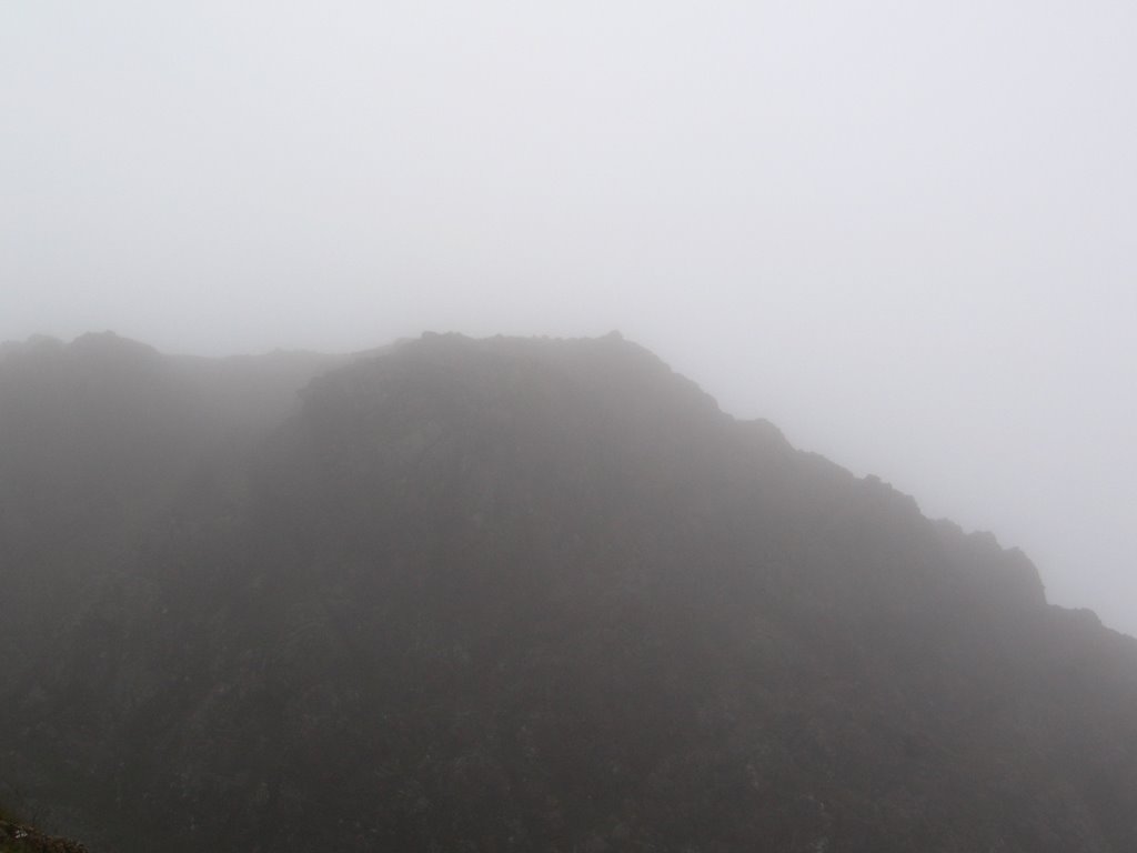
In Coire Uaigneich, the slim Isle of Skye Walks guidebook contains the following cryptic advice: "It's easy to miss the turn. If you see a large boulder on your left, you've gone too far. Retrace your steps to the stream. Follow the indistinct path over rocky and boggy ground." It may be important to note now that on two munro-bagging expeditions, I've yet to run into any trail guidance that wasn't verbal. Unlike in all of my previous hiking experience, there are no signs, no painted blazes, no visual clues to help you pick up a track, particularly in instances in which the trail more or less disappears. It's also important to note that, save for the day we arrived on Skye, the clouds never lifted from from atop the highest mountains. Therefore,
we couldn't even tell where the top of the mountain was, so following a logical line from the peak to our feet was out of the question.
 Looking down into Coire Uaigneich, with the "reference boulder" to the right. In the background, on the extreme left, you can see Loch Fionna-choire. The mountains block the view of Loch Scavaig from this vantage point
.
We scoured the ground, however, and found something that looked like a faint track that led to the promised "series of zigzags" with some "optional scrambling." The pitch was steep and rocky, and we rose above the coire, with vistas of a small lochan and then the open waters of Loch Slapin, Loch Scavaig and the sound between Skye and the islands of Soay and Rum to the south. More climbing into the clouds, with the wind beginning to howl in our ears. Our visibility was decreasing, the wind was increasing, and this was becoming a true expedition. Behind us, I could see a party of four coming up more quickly than we were. When they were close behind, I stopped to rest on a rock beside the trail and let them pass. We called greetings to each other. I could hear a distinct Scottish brogue. It appeared to be a family: Two parents and two teenage sons. The father, trailing behind and complaining that the rest of his family were ascending too quickly for his liking, was clad only in a T-shirt and shorts. We looked at our clothing: Waterproof jackets, wool sweaters, waterproof overtrousers, me in a stocking cap. Something about the Scots and their resilience to the cold and wet conditions on top of a Munro.
We continued to trail behind them. Up ahead, they were scrambling up a rocky gully and disappearing into the cloud. We were both beginning to fatigue and needed to stop more often for rest. At the top of the same gully, we stopped again.
"How much farther?" Mrs. W asked.
I looked upward into the cloud and shrugged.
We rose again and trudged upwards. In a few moments, we ran into the Scottish party of four heading toward us. It appeared that the father had made a concession to the weather conditions by donning a light fleece vest.
"How much farther?" I asked.
"Five minutes. Watch out for the cliffs on the right, but you should see the
trig point straight ahead."
In reality, it was more like two minutes before we saw the concrete
Ordnance Survey cylinder and a large
summit cairn. Relief seized us, not to mention a little hunger. The wind was howling a little too much for a comfortable picnic with our packed sandwiches, Mars bars and Isle of Skye Brewery beers, but taking shelter behind the cairn seemed to give us a little break from the wind.
Here's where our experience differs with McNeish's. The wind never managed to tear a hole in the clouds, and we never got the cacophony of lost geese. Any trembling we felt was confined to our tired legs. Neither did we see the "distinctly Tolkeinesque" views of the Cuillin about which McNeish writes in
The Munros. What we got was a howling wind that swirled the clouds about us.
 Mrs. Werbenmanjensen at the summit trig point
.
 Mrs. Werbenmanjensen declared her Hebridean Gold, like Chuckie Veylupek at Ironman Hawaii, the "best beer she ever had." Mine tasted good, too
.
As we sat lunching, another walker with a German or Dutch accent emerged from the cloud from the opposite approach we took. We exchanged greetings. He had thought he'd been at the summit when he'd seen a cairn a few hundred yards back, but his GPS told him otherwise. So he'd kept walking and eventually found us, and the trig point. He said goodbye and headed off into the cloud. We thought that was a good cue for us to leave, so we tossed our own rocks onto the cairn and started back the way we came.
Except ...
... something didn't feel right.
The trail had disappeared in our last few hundred feet to the summit, so picking it back up on the descent was very difficult. I had no visual cues to work with, since we could barely see more than 100 feet in front of ourselves. (Mrs. W had it worse, in that the water vapor was condensing on her glasses.) The cliffs, now on our left, seemed almost too close by all of a sudden, and most of the obvious routes down from this vantage point led into very steep gullies, the bottom of which I could not see. I couldn't tell if, at the bottom, it was a sheer dropoff or the barely perceptible track. It was as if
Christo had draped the mountain in gauze. Meanwhile, our Isle of Skye walks book had the following helpful advice: "It's easy to drift too far right and miss the start of the route down the ridge." We climbed back up to the summit, and started the descent again.
Except ...
... something didn't feel right again.
Now I was really starting to worry--as in, worry if we wouldn't be needing to call in
Mountain Rescue. I just couldn't see far enough down the mountain to be confident it was a safe route down. I couldn't find any indications of a trail, either, no matter how much we traversed the slope. But I had an ace in the hole--I'd packed a compass and an Ordnance Survey map. So, back to the summit we went. I put the map on the ground, and the compass on top. While the map didn't show a clear path to the summit, I could at least tell where the Coire Uaigneich was. I waved vaguely into the cloud and muttered, "We want to go ...
that way." Back down the slope we went.
I still couldn't see, and it really didn't seem right. As we approached the top of a rocky, scree-covered gully, I turned back and looked at Mrs. W with a look of confusion on my face. She said, "I can't climb to the top one more time." This was our route, then.
But then I noticed--a small cairn. Then another. People had been this way before! I crossed my fingers and hoped that the cairns were indications that it was a safe way down, not a dangerous one to avoid. Down into the gully we went.
The going was slow this way. Where there wasn't loose, ankle-deep scree, there were big boulders to be clambered over, getting slick as moisture condensed on them. The route was steep, very steep: If you leaned back a couple of degrees, you were sitting. I clambered my way down, carefully, doing a type of crab walk over some boulders--first crouching, then using my arms to hold my upper body off the boulder as I stepped down to the next level--or occasionally turning backwards and descending as if on a ladder.
As I got to the bottom of the gully, I heard behind me some cries of fear and the sickening sound of cascading rocks. I turned around in time to see Mrs. W rolling sideways, in a half-tucked position, and falling roughly onto some rocks. This, I feared, was a real situation for Mountain Rescue. I turned and tore back uphill, as quickly as I could over the rocks, shouting, "Are you OK?"
"Uh, yeah, I don't think I broke anything, but I'm bleeding."
Sure enough, her right hand was covered in blood. I coaxed some water from the bladder in my backpack to clean the blood away and find where the wounds were, then covered them with plasters I'd had the foresight to pack.
Her confidence was clearly shaken.
"What do you want to do?"
"Well, we have to get off the mountain." I have to admire her honesty and determination.
"How did you get over those rocks?" she asked.
I described my crab-walk technique as sitting on the rock and sliding down.
"I think I'm going to do that."
So down we continued, with Mrs. Werbenmanjensen sliding over the sharp rocks on her buttocks, in a modification of my technique.

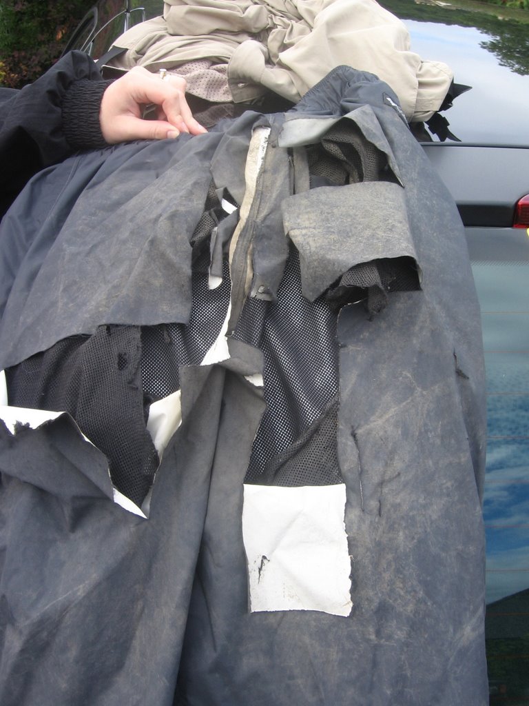
Our progress was slower. After a period of descending this way, we stopped to rest. I noticed that the seat of Mrs. W's waterproof trousers had torn and her regular trousers were showing through.

At another rest break, I noticed her regular trousers had torn through and that I could see her pants (English usage).
But given that her confidence was already shaken, and that there was absolutely nobody else on the mountain to see, I didn't feel like it was worth burdening her further.
(At this point, I must apologize for how heavy the prose has gotten here. This is not a
Jon Krakauer story, nor is it even a
Readers's Digest "real life adventure" story. This is just an inexperienced fool who had a scare and his very patient wife.)
Soon after, she asked, "Is it me, or are the rocks getting sharper?" I said something noncommittal. But the grade of the mountain seemed to be easing, and at times she was feeling confident enough to return to her feet. I assisted by pointing safe footing as we descended.
At long last, we seemed to be emerging from the bottom of the cloud. We could see Coire Uaigneich below. The reference boulder, the one we were told not to pass on our way up, was below, to our left. Our route down would put us a quarter mile up the coire from where we had started our final ascent on the summit. In other words, we had done exactly what the guide book had warned against during the descent--we had drifted too far to the right.
We reached a point where we had two routes into the valley--one rock strewn, the other boggy. As I headed down the rocky way, Mrs. W asked pointed down the boggy slope and asked, "What about that way?" Good point. Bog is probably easier on buttocks than more rocks.
Through a combination of traversing, sliding, stepping and crab-walking, we made it down into the coire.
Jubilant at actually reaching something that resembled a path again, I threw myself against the reference boulder and gave it a big kiss.
It was about then that Mrs. W asked, "Did you know my trousers were torn?" I affirmed that I did, and explained my reason for not telling her. "Probably a good idea," she said, pulling her jacket over her rump. "I can still feel the wind," she said.
We picked our way through the ball-bearings section and then enjoyed the final walk through Coire a' Caise. As we walked, some things were decided: It was to be Mrs. W's last munro expedition. It was my last munro expedition without a guide--I'm far too inexperienced to try to figure out these rather indistinct Scottish tracks, and being 0 for 2 in the trail-finding category doesn't give me a whole lot of confidence about the future.
Back at the car park, I gave Mrs. W my waterproof overtrousers to wear for the ride home. It was closing in on 9 p.m., more than 10 hours after our expedition began, and the light was beginning to fade. We hoped against hope that the restaurant kitchens in Portree would still be open, as our lunches had long since been digested and we were feeling a serious hunger knock. In
Broadford, where the road to Blaven meets the main island road, a pub advertised that its kitchen was open until 9. We raced inside.
Heart of Midlothian was on the TV, trying to play its way into the
Champions League. With a cheeseburger and a pint in front of me, I could enjoy watching somebody else slide along the ground, bruising and cutting themselves instead of Mrs. W. All was well now.
And then I heard myself saying something very foolish: "You know, I hear the route up
Ben Nevis is well-marked, and thousands of people hike it every year ..."


